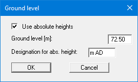
Using this menu item, you can activate the consideration of absolute heights (e.g. m AD). Then enter the new height for the ground level. The designation for the absolute height (here: m AD) can also be adapted again in the dialog box shown below.
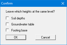
Once you have confirmed your input you will next be presented with a query on how to deal with the existing elevation data for soil strata, groundwater and footing base. If you leave the elevations at the same level (= check boxes deactivated), the originally entered data will not be modified.
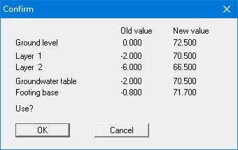
The check boxes are deactivated by default. Check the preferences and confirm your input. You will then see a message box, which compares the old and new data for you. If you used any of the previous check boxes mistakenly, you could repeat the process correctly by clicking "Cancel" in the message box. By exiting the dialog box using "OK" the new elevation data are entered into the system data.