
Use this menu item to generate geological sections, for example. All the information you need to define layer polygons is provided in a message box:
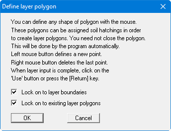
With activated "Lock on to layer boundaries" and "Lock on to existing layer polygons" check boxes it is possible to exactly position the polygon points. After completing a polygon an editor opens for additional editing of the current polygon. It can also be opened later for each defined polygon via the menu item "Layer polygons/Edit polygon" .
If you lock on to layer boundaries when defining layer polygons, the program automatically adopts the code number for the polygon fill (i.e. colour and soil signature) from the soil layer lying above the last polygon point. The last point should therefore lock on to a layer boundary. The last code number setting is adopted as the default for the next defined polygon unless you lock on to a different layer boundary again.
Layer polygons are always the first element drawn and are therefore located behind the stratigraphic logs, dynamic probings, etc. In the default state, only the reference staffs are drawn behind the layer polygons. If the reference staff lines are to be visible in front of the layer polygons, activate the "Draw reference staffs in front of layer polygons" check box in the menu item "Preferences/General".