
The most widely used function of the GGU-STRATIG program is for input and graphical visualisation of dynamic probings as stratigraphic logs. The input options available in the "Input/Stratigraphic log" menu item will therefore be introduced in detail below using a worked example.
The menu item "Input/Stratigraphic log" allows input of new stratigraphic logs or editing of existing logs. Additionally, gauge casings (backfill and/or casings) can be presented in a simplified manner. This simplified manner has a great advantage over the classical manner of well visualisation: With almost identical information content, it is much more space saving, as stratigraphic log, casing and backfill are all presented together.
Start the GGU-STRATIG program and open the"Ex_Stratigraphic log.bop" file provided with the program in the"GGU-STRATIG\Examples\en" folder. After clicking on the "Input/Stratigraphic log" menu item you will see the following dialog box:
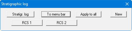
In this file two stratigraphic logs are already present, with the designations RCS 1 and RCS 2. The following actions are now possible:
-
"Stratigr. log"
The button indicates that you are using the stratigraphic log editor. After clicking the button, you change to the "Input/Well" menu item. If you have a stratigraphic log with separate well visualisation, this allows you to quickly swap between the two element editing modes. -
"To menu bar"
You return to the original menu bar. -
"Apply to all"
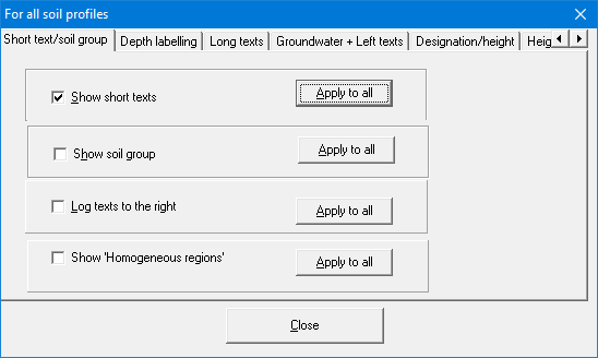
Specific settings can be defined for all stratigraphic logs by clicking this button. The settings are adopted as the defaults for all new stratigraphic logs. This can also be used to easily modify the appearance of labelling for all existing stratigraphic logs, for example. Activate the required setting and then click the "Apply to all" button displayed after the respective check box.
-
"New"
You can now enter a new stratigraphic log. -
"RCS 1", "RCS 2"
By clicking the buttons labelled with the designations (here: RCS 1 and RCS 2) you can edit the data for the corresponding stratigraphic log.