
This menu item is almost completely the same as the previous one. With the difference that a triangle mesh with rectangular structure is computed from the data points of the underlying triangle mesh. Define the fineness of the rectangular mesh by entering the number of subdivisions (plates) in x and y directions:
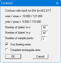
In addition, you must also give the number of control points (n) used to compute the data values at the mesh points. For each mesh point, the program uses the nearest n data points to obtain the new value for the mesh point.
If you activate the "Use floating mean" switch, the new values are calculated from a plane equation for n data points. Otherwise, the squares of the distances are used. In the above dialog box the minimum x and y coordinates of the triangle system are given.
If the "Complete rectangular area" switch is activated, the program computes new array points within this rectangular area. Otherwise, only array points with x and y coordinates within the underlying triangle mesh are calculated. In particular for a triangle mesh with an exterior shape which deviates substantially from a rectangle, nonsensical extrapolation of new values can thus be avoided.