
Using this menu item you can define the positions of points with a mouse click. This is particularly beneficial if you first import a scanned site map as a graphic or DXF file containing the locations of the data points using the Mini-CAD system.
After selecting the menu item, you can define a designation, which can also be automatically supplemented with sequential numbering (Bo 1, Bo 2, Bo3, etc.), in the following dialog box. Moreover, a value can be selected for entry when defining points, e.g. ground level.
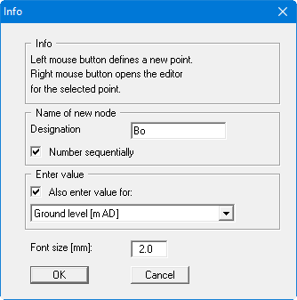
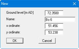
After confirming your settings by pressing "OK", click the required position of your point on the screen using the left mouse button. An input box opens, in which you enter the value for the new point. The point designation and coordinates are entered by the program, but can, if required, be corrected in the input box.
You can also use this menu item to edit existing individual points or to delete them. To do this, right-click on the existing point. The same editor box opens as that seen via the menu item "Edit / Define points (editor)" for the individual points.