
New values can be generated from existing ones using this menu item. After selecting this menu item the following dialog box appears:
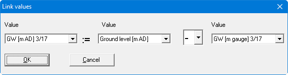
For example, if you want to graphically represent the following values:
-
ground level in m AD,
-
groundwater-surface distance in m,
-
groundwater surface in m AD,
you generally have the values for "Ground level [mAD]" and "GW [m b GL]" available as measured data. The third value results from the difference between measured values 1 and 2. In principle, you could calculate the third value "by hand" and enter it using "Edit/Define points (editor)" or "Edit/Individual values". But with this menu item the program can do this work for you. If you fill in the dialog box as shown above and then click "OK", the value "GW [m AD]" will be assigned the difference between values 1 and 2. This is calculated from the values previously entered by the user. The four basic mathematical operations can be used to link data.
If, after linking data, you change a value, e.g. "Ground level [mAD]", the link operation must be performed once again in order to adjust the calculated result of the link operation.