
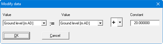
In analogy to the previous section, operations can be performed by applying a constant. This can be useful, for example, if you entered an incorrect AD height for ground level during the first data evaluation phase. You can then correct this value for all data points by entering the appropriate correction value as the constant.
If you need to display the measured data in colour in a subsequent evaluation, a measured value may need to be visualised at a different position in the sequence. Otherwise it would be covered in section by one of the other values. Recreate the required value again in the last row in "Edit/Value names" and, using this menu item, copy the required values to the new one at the bottom (new value = old value * 1).